
Designated height road, Designated weight road
With designated road
-
- ◆ "Designated height road"
- A "designated height road" is a road designated by the road manager as having a general height limit of 4.1 m, which is deemed to have no problem in maintaining the structure of the road and preventing traffic hazards. is.
(Even if the height exceeds 3.8m, it can run freely under certain conditions if it is 4.1m or less.)
-
- ◆ "Weight designated road"
- A “weighted road” is defined as a general limit on the total length of the vehicle and the wheelbase when the road manager recognizes that there is no problem in maintaining the road structure and preventing traffic hazards. A road designated as a maximum of 25 tons accordingly.
-
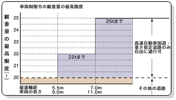
| Gross weight | 20 tons | The farthest wheelbase is less than 5.5 meters |
|---|---|---|
| 22 tons | The farthest wheelbase is 5.5 m or more and less than 7 m, and the length is 9 m or more with no cargo loaded. 20 tons for less than 9 meters | |
| 25 tons | The farthest wheelbase is 7 meters or more, and no cargo is loaded and the length is 11 meters or more. 20 tons less than 9 meters, 22 tons from 9 meters to 11 meters |
指定道路
-
- (1) National highway
- All highway national roads managed by Central Nippon Expressway Company Limited are designated as "designated height roads". In addition, vehicles with a total weight of up to 25 tons can travel freely on the entire line, depending on the length of the vehicle and the wheelbase.
-
Height designation Weight designation 東名高速道路(全線) ○ Highway National Road
By vehicle restriction order,
Depending on the length of the vehicle and the wheelbase,
Gross weight up to 25 tons
Vehicles can run freely.Tokai-Hokuriku Expwy (all lines) ○ 中央自動車道(全線) ○ 東名阪自動車道(全線) ○ Meishin Expwy
(Komaki IC-Yokaichi IC)○ 伊勢湾岸自動車道(全線) ○ Nagano Expressway
(Okaya JCT-Azumino IC)○ 新東名高速道路(全線) ○ Shin-Meishin Expwy
(Yokkaichi JCT-Kokatsuchiyama IC, Kameyama JCT-Kameyamanishi JCT)○ 中部横断自動車道(全線) ○ Ise Expwy (all lines) ○ Hokuriku Expwy
(Yonehara JCT-Asahi IC)○ 紀勢自動車道(全線) ○ Ken-o Expressway (Ken-O Road)
(Ebina JCT~Ebina IC)○ Mei-Nikan Expwy (all lines) ○ Maizuru-Wakasa Expressway
(Obama IC-Tsuruga JCT)○
-
- (2) General toll road
- About general toll road which Central Nippon Expressway Company Limited manages, "height designated road" and "weight designated road" are appointed as shown in the following table.
-
Height designation Weight designation Odawara-Atsugi Road (all lines) ○ ○ Shin-Shonan By-Pass (all lines) ○ ○ Seisho By-Pass (all lines) ○ ○ Higashi-Fujigoko Road (all lines) ○ ○ Ken-o Expressway (Ken-O Road)
(Ebina IC-Akiruno IC,
Ebina JCT~Chigasaki JCT)○ ○ Isewangan Expressway road (all lines) ○ ○ Tokai-Kanjo Expwy (all lines) ○ ○ Chubu-Jukan Expwy (Abotoge Road) - -
Passage method (condition) when we pass "height designation road"
- When vehicles over 3.8m in height and 4.1m or less pass on "designated height road", please follow the following conditions.
-
- Designation of travel position
- At the obstruction point in the sky such as a tunnel, the vehicle or the cargo loaded on the vehicle may violate the construction limit.Therefore, drive so that it does not protrude from the lane, and unavoidably protrude from the lane to enter and exit facilities adjacent to the road. In such a case, take care to avoid contact with obstacles such as signs and trees.
- Rear warning measures
- In order to allow the following vehicles to keep a sufficient distance between them and prevent traffic danger, the ground with a horizontal dimension of 0.23 meters or more and a vertical dimension of 0.12 meters or more (or a horizontal dimension of 0.12 meters or more, a vertical dimension of 0.23 meters or more) is black A sign indicating “tall” with a yellow reflective paint or other reflective material on a board or the like shall be placed at an easily visible place behind the vehicle.
- Collection of road information
- Road conditions may change due to construction work. Collect road information in advance and confirm that there are no obstacles in the sky before traveling.
